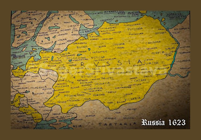
It took several centuries for Russia to become what it is today. Starting from the Grand Principality of Rus' (or Kievan Rus') in 862 AD, it wasn't till the end of the 19th century when Russian borders extended from Finland to Kamchatka and covering entire Central Asia. But let's go back a few millennia into the 17th century when trade and commerce were at their full swing and every European coloniser was acquiring lands to add to its empire.
In the early 17th century, Russian borders were limited between the Ob River in the east and the Onega River in the west, tapering Livonia and Curlandia (Courland) in the far west. Pockets of Russian territories can also be seen marked on certain old maps in Prussia (the territory of Kaliningrad), the territory between Polonia (Poland) and Volhinia (Volhynia; spread around northwest Ukraine and parts of Belarus and Poland), and the territory of Podolia (in today's Ukraine). This was the time when there existed a huge territory that was a union of Polish and Lithuanian kingdoms, commonly known as the Crown of the Kingdom of Poland and the Grand Duchy of Lithuania. It covered entire northeast Europe lying between Russia and the borders of Hungary and Romania. This would mark the western frontier of 17th century Russia. A Polish territory of Mazovia would also mark its westernmost border, lying south to Kaliningrad or East Prussia. The territory of Podolia would touch Transylvania and Moldavia in the south, much of which is in today's Romania. At this time, Crimea and southern Ukraine would be denoted by Crimea seu Tartaria Przecopensis translating to Crimea and Perekop Tartary. The Asian boundary would be today's borders of Kazakhstan, Mongolia, China and Siberia, much of which would be then known as Tartaria or Tartary.
Coming to the Russian homeland, the country in the 17th century was divided into numerous factions known as Voivodeships. These are listed below as follows:
- Livonia - marking today's Latvia and Estonia.
- Cvrlandia (Courland) - the westernmost part of Latvia.
- Moscovia (Moscow) - the territory between Novgorod and Tver would mark the Moscovia Voivodeship. It would also border a territory marked as Polocensis, along the Daugava river crossing through northern Belarus.
- Smolenkia (Smolensk Oblast)
- Seueria - the territory around the Desna River passing through central Ukraine.
- Msczenecia - The Don River flowing through southern Russia draining into the Caspian Sea would mark the southern boundary of Russia towards the Caucasus mountains.
- Mordwa (Mordovia Oblast)
- Wlodimiria (Vladimir Oblast)
- Bulgaria - interestingly, the region marked as Bulgaria on several older maps don't really point to today's sovereign nation of Bulgaria. This region would be around the Volga River tapering north of the Caspian Sea.
- Cazan (Republic of Tatarstan and neighbours)
- Permia (Perm Krai) - marking the easternmost border towards the Central Asian Steppes.
- Sibior - bordering Ioughoria to its east, this region would separate out the rest of Asian territories by the Ob River. The territory of Ioughoria would translate in Russian as Yugra, a group of indigenous people between the Pechora River and the Urals. This could also point to the starting of Siberia as the westernmost portion of the territory was part of the Tsardom of Russia in the early 1600s.
- Obdora - the territory separated by the Ob River to its west and neighbouring a region called Molgomzaia (today's Mangazeya, western Siberian border) to its east would mark the end of the Russian boundary towards the east.
- Petzora (Pustozersk) - marking the northernmost boundary opening to the Arctic Ocean (marked as Petzorke Mare) this was the first town built by the Russians in the Arctic Circle.
- Dwina (around the Northern Dvina River) - the coastline of this territory would touch Album Mare which is today's White Sea.
- Wologda (Vologda Oblast)
- Nouogardia (Novgorod Oblast)


0 Comments